Impact of Unusual Temperatures in the Arctic Remains Uncertain
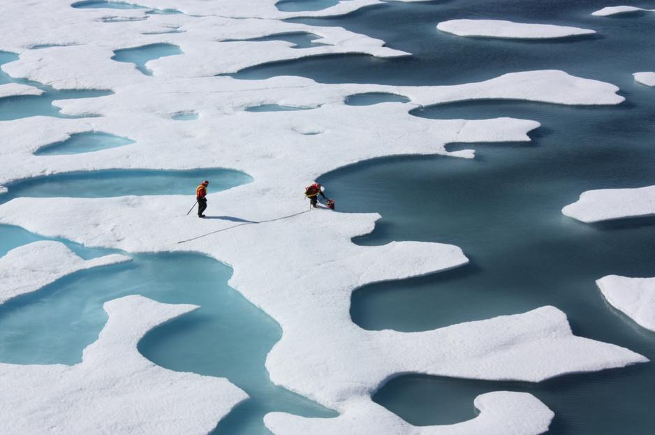
NASA scientists studying the Arctic Ocean’s ecosystem (Photo: NASA/Kathryn Hansen)
For much of the past two weeks large areas of the Arctic have experienced unusually high temperatures, at times exceeding 20C degrees above the long term average. This notable weather pattern follows on the heels of a record-low ice extent in October and November. How unusual are weather patterns such as this and what will the impact be on Arctic sea ice extent?
For much of the past two weeks large areas of the Arctic have experienced unusually high temperatures, at times exceeding 20C degrees above the long term average. This notable weather pattern follows on the heels of a record-low ice extent in October and November. How unusual are weather patterns such as this and what will the impact be on Arctic sea ice extent?
The remarkable weather pattern bringing warm temperatures began around the middle of November when temperatures, already tracking above the long-term average, spiked further. Temperatures were highest over much of the Arctic Ocean as well as the Canadian archipelago and the Barents region. In contrast, Russia’s Far East experienced very frigid temperatures.
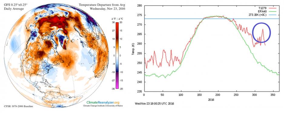
Illustration on the left side: Air Temperature anomaly in the Arctic on November 23rd. Illustration on the right side: Average daily temperature in the Arctic above 80 degrees latitude during 2016. Blue circle indicates current warming event. (Source: Climate Change Institute/University of Maine and Danish Meteorological Institute)
Jetstream transports warm air into Arctic
How did this weather pattern get set up? Jennifer Francis, research professor for marine and coastal science at Rutgers University, explains that the low ice extent this fall meant more heat was absorbed and contained in the Arctic Ocean reducing the temperature difference between the Arctic and lower latitudes. This likely resulted in a “very wavy jet stream which helped transport extra heat and moisture from lower latitudes northward into the Arctic.” The moisture in turn allows more clouds to form which in turn trap heat further amplifying the warming.
James Overland, research oceanographer at the National Oceanic and Atmospheric Administration (NOAA), agrees that the jet stream is involved in the current event, but adds that “the current case is so far out there compared to previous years” that it could usher in some long term changes. His recent research also attempts to show a connection between this wavier jet stream and its impact on weather events in the mid-latitudes such as continental Europe. What happens in the Arctic rarely stays in the Arctic.
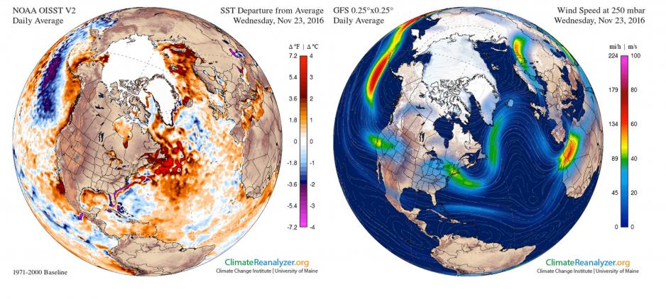
Illustration on the left side: Water temperatures anomaly in the Arctic on November 23rd. Illustration on the right side: Wavier jet stream pattern on November 23rd bringing warmer air into the Arctic. (Source: Climate Change Institute/University of Maine)
Temperature spike connected to climate change?
While the recent spike in temperatures is noteworthy, its connection to the ongoing long-term warming trend in the Arctic remains uncertain. Mark Serreze, Director of the National Snow and Ice Data Center in Boulder (NSIDC), Colorado, cautions to not “read too much into extreme events.” He further adds that “while the Arctic is clearly getting warmer this event is superimposed upon that overall warming trend.” This makes it harder to fully understand its cause and impact.
In fact, similar short-lived warming events have occurred in the past for example in December 2015, February and November 2014, and January and March 2012. Even before the widespread melting of sea ice began in the 2000s temperature spikes occurred at times, such as in November 1996 when temperatures also rose similarly to this past week.
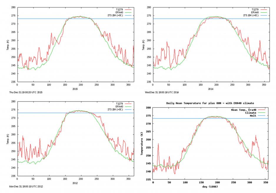
Average daily temperature in the Arctic above 80 degrees latitude during 2015, 2014, 2012 and 1996. (Source: Danish Meteorological Institute)
Ice too weak to withstand unusual weather patterns
One key difference to temperature spikes 20 or 30 years ago, is the fact that Arctic sea ice has become much weaker which in turn makes it more difficult to withstand unusual weather events, explains Serreze. As the ice has become weaker and thinner over the past two decades it has become much less resilient.
Thicker multiyear ice, which is less affected by unusual weather patterns such as strong winds or warmer temperatures, now accounts for only three percent of ice in the Arctic Ocean, compared to 20 percent in the 1980s. Multiyear ice acts like a glue holding together the ice especially at the end of the summer when all the younger and weaker ice has melted. That icy glue is all but gone in most parts of the Arctic Ocean.
A winter of uncertainty for sea ice
As of now it remains uncertain what the exact impact will be on sea ice going into 2017. “The ice will grow this winter, but it will occur more slowly than normal due to all the extra heat in the system,” explains Francis. She also expects ice cover to be abnormally thin come spring time.
Serreze, on the other hand, cautions that it is too early to tell what exactly the impact of this weather event will be on Arctic sea ice. However, if this warming period continues or if another warming event occurs later this winter, “we will end up with a lot of thin ice in March, which could be a setup for a very low September sea ice minimum in 2017,” Serreze added.
As to the impact next summer, both Serreze and Francis agree that weather patterns are the unknown wild card. All it takes is a few weeks of warm temperatures during the summer to melt out the weakened ice. On the other hand if cool and cloudy weather conditions prevail during the summer months we could get lucky as we did in 2016 “saving us from a new record low,” Serreze concluded.