U.S. Coast Guard Moves Forward with Proposed 4-mile-wide Arctic Shipping Corridor Near Alaska
")
U.S. Coast Guard icebreaker Healy in the Arctic conducting survey and mapping work. (Source: U.S. Coast Guard)
The U.S. Coast Guard and partnering federal agencies plan to organize shipping activity along a designated corridor to protect the marine environment and local communities. The route would lead from Western Alaska in the Bering Strait to the U.S.-Canada border in the Beaufort Sea. Survey work carried out by icebreaker Healy helps inform the exact routing of the corridor.

The U.S. Coast Guard, in cooperation with other federal agencies, is moving forward with proposing a two-directional shipping corridor from Alaska’s Bering Strait to the U.S.-Canada border in the Beaufort Sea.
The proposed shipping lane aims to minimize impacts of increased shipping activity on marine mammals and local indigenous communities relying on the marine environment. The effort is organized under the Alaskan Arctic Coast Port Access Route Study (AACPARS).
The corridor is the result of a multi-year collaboration between the U.S. Coast Guard, the National Oceanic and Atmospheric Administration (NOAA) and U.S. National Science Foundation as well as the University of New Hampshire to survey the route and conduct a coordinated mapping effort.
“The interagency science mission along the north slope of Alaska combined oceanographic buoy and mooring deployments with a coordinated mapping effort to survey uncharted waters and acquire depth data along the Coast Guard-proposed Arctic Port Access Route Study corridor,” NOAA said in a progress report.
The four-mile wide channel is set to organize two-way shipping traffic along a 1,000 nautical mile route aiming to avoid environmentally sensitive areas and potentially hazardous waters, such as the key marine area of Hanna Shoal.
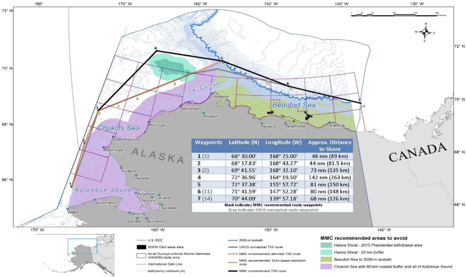
Map of the proposed corridor status November 2020. (Source: Marine Mammal Commission of the U.S. Government)
The goal of the corridor is to provide a traffic separation scheme creating buffer zones between vessel traffic along a two-way route, while also taking into account the need for sufficiently deep-waters.
Once adopted by the International Maritime Organization (IMO) such a corridor could become mandatory for all ships in the area or for vessels with certain hazardous cargoes.
Icebreaker helps with mapping work
The U.S. Coast Guard icebreaker Healy conducted underwater mapping and bathymetric surveys along the corridor in October and November 2024. The data helped inform the preferred route from Utqiaġvik, Alaska in the Bering Strait, to the U.S.-Canada border.
NOAA conducted additional survey work this summer.
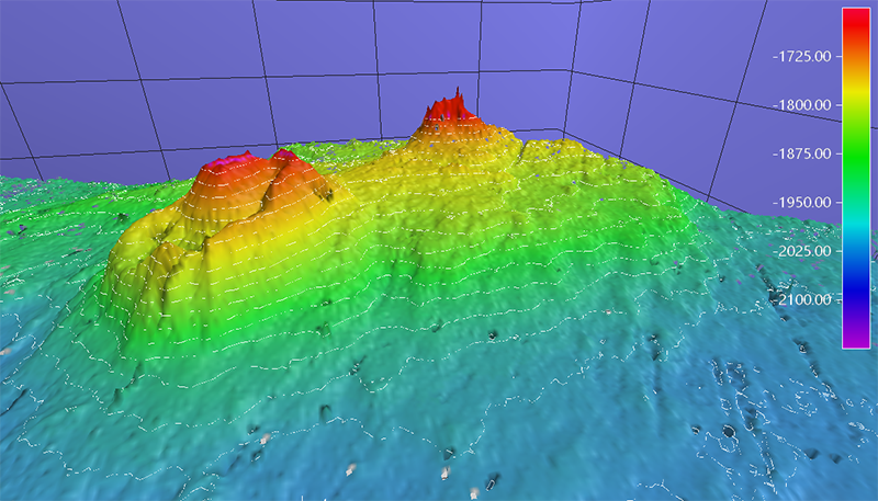
Much of the Arctic region remains poorly surveyed, with 73 percent of the U.S. Arctic waters of the Exclusive Economic Zone remaining unmapped.
The largely unknown waters allow for exciting scientific discoveries, as when the crew of icebreaker Healy discovered a volcano-like structure rising 500 meters above the surrounding seabed last year.
")
Members of the hydrographic team from the National Oceanic and Atmospheric Administration Ship Fairweather and the University of New Hampshire analyze mapping data in the U.S. Coast Guard Cutter Healy’s computer lab while the cutter transits the Beaufort Sea, Oct. 16, 2024. (Source: U.S. Coast Guard photo by Lt. j.g. Haley Howard)
“The route planning really did take into consideration mammal migration patterns in order to minimize the amount of impact the shipping would have on these environmentally sensitive areas,” Coast Guard Officer Camden Martin told Alaska news outlet KNBA.
The AACPARS corridor would complement and extend northwards a Bering Sea shipping lane jointly proposed by the U.S. and Russia and adopted by the IMO in 2018.
That proposal put into effect six two-way routes and six precautionary zones in the waters of the Bering Sea between the two countries.
")
")