Arctic Encounter Summit 25: Summer Season is also Fire Season in Alaska
Dr. Nettie La Belle-Hamer (left) speaking at the Arctic Encounter Summit seminar Wildland Fire - from Research to Operations in the Arctic. To the right: Research Liaison and Program Coordinator Ms. Hilary Shook from the Alaska Fire Science Consortium and Mr. Peter Butteri, Alaska Statewide Fire Planner (ret.), U.S. Fish and Wildlife Service. (Photo: Hilde Bye).
Anchorage, Alaska (High North News): "The wildland fires are a huge problem for us. Millions of acres of Alaska burn every year," says Deputy Director of the University of Alaska Fairbanks Geophysical Institute.
"As someone who breathes smoke most of the summer, I can tell you, Alaska fires have a huge impact on Alaskans," says Dr. Nettie La Belle-Hamer, Deputy Director of the University of Alaska Fairbanks Geophysical Institute.
"The wildland fires are a huge problem for us. Millions of acres of Alaska burn every year," she adds.
High North News sits down with La Belle-Hamer at the Arctic Encounter Summit 25 in Anchorage, Alaska, where she is organizing and participating in a session on wildland fires.
It is late July, and summer in the Arctic state. However, the summer season here is also called fire season.
There are currently 459 fires in the state of Alaska, according to data from the Alaska Interagency Coordination Center.
"I've lived in Interior Alaska for 40 years and have dealt with the smoke from the fires pretty much my whole life," says Dr. Nettie La Belle-Hamer who is Deputy Director at the University of Alaska Fairbanks Geophysical Institute. (Photo: Hilde Bye).
The fires can sometimes burn all winter as well due to the nature of tundra and permafrost, but then they are beneath the snow, La Belle-Hamer explains.
Enormous areas burning
"I don't think a lot of people in the lower 48 states understand what we are dealing with in Alaska in terms of size. This does not hit the mindset of people, as a lot of the land is uninhabited by humans, or the villages that are affected are relatively small. But, it is still what happens to our ecosystems, wildlife, the environment, and land that we have food security dependencies on," La Belle-Hamer notes.
"And it also affects all of Alaska, because of the smoke. So, there is a lot to it," she adds.
Satellite imagery
The Deputy Director has a background in basic physics and has worked with remote sensing and earth observations for several years. For 20 years, she was the director of the Alaska Satellite Facility.
"One of the things I've been working on for the last few years is the wildland fires. It started with the mapping that we have been doing for the Arctic, funded by the Department of Defense," she tells HNN.

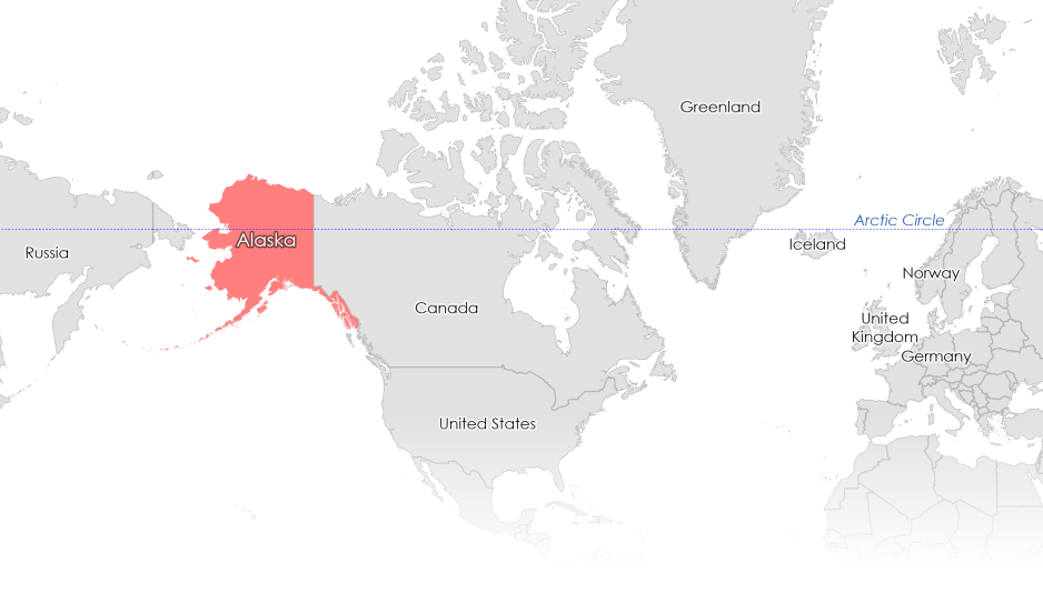
Alaska is by far the largest state in the US and is over twice the size of Texas - with a limited road network and sparsely populated areas in large parts of the state. (Map: Shelby Duncan / Maptyx).
"Until very recently, our maps had not been updated since the 1940s, so even though the rest of the United States has very detailed maps, it was always a challenge for us because this is a large space. Now, we've done that mapping from satellite imagery, and it has changed things a lot."
La Belle-Hamer emphasizes the dependence and significance of satellite imagery. The satellite imagery is important for giving the fire community the information they need.
"Part of the information is useful for wildland fire mitigation; we see what the forest looks like, what the state of the trees is – not just in terms of density, but for instance in terms of diseases – and you can see a lot of that from satellite imagery."
"So, for instance, if a spruce bark beetle kills a lot of trees, those are more likely to catch on fire than a live tree. It changes the fuel that is available for the fire. If a spark does hit, it is more likely to ignite," she says.
Most of the fires are caused by lightning strikes, and are not man-made as with a lot of the fires in the lower 48 states, La Belle-Hamer further explains.
We still fight fires the same way we used to.
"I'm not sure people understand just how important satellite imagery is to the work that we do here. Here in Alaska, we can't just say, 'hey, go drive out to the end of that road, and tell me (...).' We can't do that. We do a lot of the fire spotting with the satellite data."
For the fire fighter community, tools provided by researchers are essential, echoed Peter Butteri, a retired Alaska Statewide Fire Planner with the US Fish and Wildlife Service.
"Over the past 40 years, the boots on the ground stuff has not really changed a lot; we still fight fires the same way we used to, but we have better tools. We've worked closely with the Alaska Fire Consortium, with different researchers, with NASA."
"It's critical to have these specialized tools that these researchers are providing for us. We've got long-term researchers that has been providing tools that we use on a daily basis, and that has only increased our effectiveness."
Budget cuts
La Belle-Hamer further emphasizes the significance of collaboration between different entities and groups in mitigating the fires.

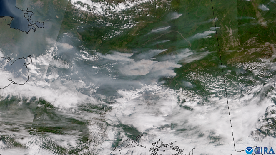
Numerous wildfires burn across the interior of Alaska, filling the sky with smoke in July 2025. (Image: CSU/CIRA & NOAA/NESDIS)
"We are all reliant on each other. This is not just a fire service problem, it's also NOAA - the National Oceanic and Atmospheric Administration's problem, NASA's problem, and our problem – the people who live here. So we work together in a way that I think could be modeled in other parts of the world."
"The problem that we currently have, however, is the budget cuts," she says with reference to the recent federal cuts under the current Trump administration.
"The budget cuts to NOAA, for example, have really hit us in the wildland fires mitigation sector. And because we rely on satellite imagery, it is a problem if we no longer have the imagery, or don't have the people to interpret the imagery. It's a complicated thing when you have integrated collaboration between many different units, both state, federal and local. If you take out one [unit, ed. note], it affects all of us."
Wildland Fires Initiative
In 2023, the Norwegian Chairship of the Arctic Council launched the Wildland Fires Initiative to address and elevate wildland fires as an urgent climate issue on the Council’s agenda.
"Wildland fires are a growing emergency, and a prime example of why we need circumpolar cooperation. Wildland fires, their smoke, and their impacts to communities, ecosystems, and the climate are transboundary," said Chair of the Arctic Council, Morten Høglund, at the time.
At the seminar at the Arctic Encounter Summit, Høglund further emphasized the importance of the issue, noting a recent report from the Arctic Council on the topic.
"We also make a number of recommendations. And I think these will work very well from the local, regional, national and even at the multinational level – to have a discussion on what we do now. Yes, the fires are happening. How do we combat them? How do we mitigate them? How do we adapt when the fires are happening? And, what can indigenous knowledge teach us? And here I think we have a lot to contribute to this debate, which has been overlooked," Høglund concluded.
Consequences of wildland fires in the Arctic
- Smoke degrades air quality and can damage human health
- Ecosystems and local food sources are altered
- Fires can threaten life and property
- Black carbon and other emissions from fires further accelerate warming
- Climate change is expected to further increase the length of the fire season, possibly create drier conditions and increase the number of lightning strikes.
- The number of fires has more than tripled since 2018 in much of the Arctic.
Source: The Arctic Council, Global Wildland Fire Information System.


