Arctic permafrost mounds: More than 400 sealed ‘craters’ are ticking time bombs

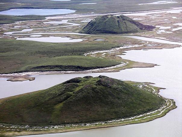
Unerupted Pingos near Tuktoyaktuk, Northwest Territories, Canada. A pingo, also called a hydrolaccolith, is a mound of earth-covered ice found in the Arctic and subarctic that can reach up to 70 metres (230 ft) in height and up to 600 m (2,000 ft) in diameter. (Photo: Emma Pike)
The mounds are believed to be caused by the build up of methane gas in pockets of thawing permafrost under the surface Dissecting them like surgical abscesses to release the gas is seen as one solution to avoid future eruptions.
There are 17 identified funnels of exploded so-called ‘heave mounds’ recorded on the Yamal and Gydan peninsulas in Arctic Russia since the first ’crater’ known as C1 started the history of observations in summer 2014.
You can read the whole story in Siberian Times.
They are believed to be caused by the build up of methane gas in pockets of thawing permafrost under the surface; these swollen pingo-like formations then erupt with gas blowing off thick caps of soil, shooting out chunks of ice and soil as large as 150 cubic metres as happened in 2017 when the Seyakha pingo erupted.
The newest - number 17 on Russian scientists’ list - ‘crater’ appeared earlier this summer in an undisclosed location on the Yamal peninsula.
It is currently 31 metres (102 ft) deep, although scientists believe that it was about 40 metres (131 ft) deep at the moment of eruption, with the bottom of the crater quickly covered by collapsing soil.
Also read
Currently several areas in the Arctic - namely the Seyakha area, the North-Tambey area, the South-Tambey field close to the village of Sabetta, and the West-Seyakha gas field - are on the list of ‘the most dangerous sites’ with the highest concentration of the pingo-like mounds.
The process of these mounds forming and exploding is now mostly clear to science, with researchers focusing on how to distinguish the dangerous mounds from the non-explosive ones, and, most importantly, on how to prevent future eruptions. Pingos usually form in the depressions of dried up lakes (khasyrei) and have an ice core which expands and makes them grow.
In the formation of the pingo-like features in northern Siberia, the methane migrates from deeper layers through sub-vertical faults in thawed zones (cryopegs) to fill a cavity formed in permafrost. Usually such cavities are covered by a 7 to 9 metre thick seal of permafrost.
The volume of the chamber increases under the growing pressure from the gas and eventually blows up the seal with massive chunks of frozen rock and soil thrown as far as 900 metres from the epicentre.
The term pingo originated as the Inuvialuktun word for a small hill. A pingo is a periglacial landform, which is defined as a nonglacial landform or process linked to colder climates. They are essentially formed by ground ice which develops during the winter months as temperatures fall.


