The U.S. Initiates Extended Continental Shelf Claims

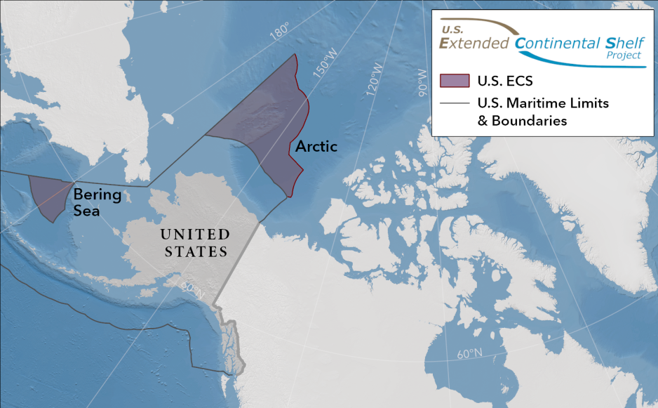
The U.S. Department of released the geographic coordinates defining the outer limits of the U.S. (Map: US Department of State)
Tuesday, the U.S. Department of State announced plans to move forward with extended continental shelf claims in the Arctic.
Tuesday, the US Department of State released the geographic coordinates defining the outer limits of the U.S. continental shelf in areas beyond 200 nautical miles from the coast, known as the extended continental shelf (ECS). The continental shelf is the extension of a country’s land territory under the sea.
Like other countries, the United States has rights under international law to conserve and manage the resources and vital habitats on and under its ECS, the Department states.
The U.S. ECS area is approximately one million square kilometers spread across seven regions. This maritime zone holds many resources, like strategic minerals and rare earth elements needed for everything from green energy to the semiconductors that drive Artificial Intelligence, as well as being a vital habitats for marine life like crabs and corals.
This is a monumental step, according to Arctic Research Professor Abbie Tingstad at the Center for Arctic Study and Policy, U.S. Coast Guard Academy;
"Especially for its Arctic interests given the need to protect this unique region while enabling sustainable economic activities", Tingstad writes in an analysis for the Wilson Centre.
Yet to ratify UNCLOS
"Unfortunately, the significance of this step is muted by the implementation and credibility challenges the U.S. will face as a consequence of its continuing failure to ratify the UN Convention on the Law of the Sea (UNCLOS), in which the process for arbitrating ECS claims is laid out, among many other areas of important maritime governance", says Tingstad.
UNCLOS has been ratified by 168 states and the European Union.
Article 76 of UNCLOS provides a mechanism for coastal states to claim additional economic rights with respect to resources on or below the seabed beyond the 200 nautical miles of the exclusive economic zone (EEZ) if they can demonstrate, through geology and bathymetric mapping, that there is a natural extension of their continental shelves.
Raised questions
U.S. neighbors Canada and Russia, and other Arctic nations have made ECS claims in the high north through UNCLOS. Numerous states including France (closely behind the U.S. in EEZ size) and China have submitted claims to the UN to extend continental shelves around their EEZs as well.
"Although the U.S. abides by UNCLOS in practice, not formally ratifying it has raised questions about the extent to which the nation can or cannot formally make ECS claims or dispute those of others", Tingstad says.
The Department of State led the ECS effort through the U.S. ECS Task Force, an interagency body of the U.S. Government composed of 14 agencies.
Largest ever mapping
Determining the ECS outer limits requires data on the depth, shape, and geophysical characteristics of the seabed and subsoil. The National Oceanic and Atmospheric Administration (NOAA) and U.S. Geological Survey (USGS) were responsible for collecting and analyzing the necessary data.
Data collection began in 2003 and constitutes the largest offshore mapping effort ever conducted by the United States.
The United States has determined its ECS limits in accordance with customary international law, as reflected in the relevant provisions of the 1982 United Nations Convention on the Law of the Sea, and the Scientific and Technical Guidelines of the Commission on the Limits of the Continental Shelf.
The continental shelf (ECS):
The extension of a country’s land territory under the sea.
In seven U.S. regions: the Arctic, Atlantic (east coast), Bering Sea, Pacific (west coast), Mariana Islands, and two areas in the Gulf of Mexico.
Countries has exclusive rights to conserve and manage the living and non-living resources of its ECS
Defined in the 1982 UN Convention on the Law of the Sea, and the outer limits are determined using the rules of Article 76.
Not an extension of the exclusive economic zone (EEZ).
Includes only the seabed and subsoil, whereas the EEZ also includes the water column.
May extend beyond 200 nautical miles of the EEZ.
The U.S. ECS partially overlaps with ECS areas of Canada, The Bahamas, and Japan.
The U.S. has already established ECS boundaries with its neighbors, including with Cuba, Mexico, and Russia.
Source: U.S. Department of State


