NASA Launches Next Generation Satellite to Monitor Arctic Sea Ice
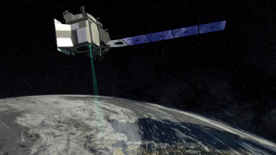
Illustration of ICESat-2 in orbit around Earth. (Source: Courtesy of NASA)
The North American Space Administration (NASA) will be sending a groundbreaking new satellite into a Polar orbit on September 15th. The ICESat-2 mission carries a single instrument, the Advanced Topographic Laser Altimeter System (ATLAS), which uses laser pulses to precisely measure the Earth’s ice, land, and water surfaces.
The North American Space Administration (NASA) will be sending a groundbreaking new satellite into a Polar orbit on September 15th. The ICESat-2 mission carries a single instrument, the Advanced Topographic Laser Altimeter System (ATLAS), which uses laser pulses to precisely measure the Earth’s ice, land, and water surfaces.
ICESat-2 follows on the heels of the original ICESat mission which ran from 2003 to 2009 and provided, among other data, information on Arctic sea ice extent.
The new satellite represents a vast technological upgrade over the original ICESat. While the previous spacecraft sent 40 laser pulses per second, the new mission will shoot 10,000 pulses per second allowing ATLAS to take measurements every 2.3 feet as the satellite circles around the Earth at 24,900 kilometers per hour.
"The technological differences between ICESat and ICESat-2 are tremendous. ICESat was a single beam laser with a footprint size of 70 m and laser shots every 150 m. ICESat-2 in contrast has 6 beams, the footprint size is 17 m or better and laser shots every 0.7 m," confirms Thorsten Markus ICESat-2 project scientist.
Shooting laser beams at Earth
ICESat-2’s laser pulses will be used to precisely measure the distance between the spacecraft and the Earth’s surface. The laser pulses bounce off the planet and reflect back to the satellite where they are detected by a 80 cm diameter telescope. Based on the length it takes for the light photons to return to space scientists can then calculate the height of Earth’s ice, land and water surface, and vegetation.
"The satellite will use a new kind of laser system which is substantially different from that on ICESat. The original ICESat mission used a traditional analog laser which sent out a large amount of energy each shot. ICESat-2 uses a much lower energy laser which counts individual photon events. The lower laser energy level should also allow for a much longer lifetime," explains Nathan Kurtz deputy project scientist for ICESat-2.
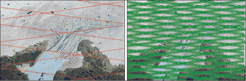
Comparison of the amount of detail laser pulses of ICESat-1 (left) and ICESat-2 (right) can capture. (Source: Courtesy of NASA)
The instruments on the satellite are so precise that they can detect individual photons bouncing back from the Earth’s surface. Each pulse sends out around 20 trillion photons, of which only a dozen or so will reflect back to the satellite’s telescope.
The ATLAS instrument will generate vast amounts of data stored aboard a 580 gigabit hard drive and subsequently downloaded every other orbit to Earth using a 220 megabit X-band connection, about 10 times faster than your average cable internet connection. One of the download ground stations is located on the archipelago of Svalbard.
Looking at the Arctic
Of particular interest are the two polar regions where scientists for the first time can track the development of ice over time. For this purpose the spacecraft’s orbit is aligned to repeat every 91 days. The combination of precise and frequent measurements over the same area will allow scientists to determine where ice is declining or expanding and how ice floes are moving through the Arctic.
"Year-round data coming from ICESat-2 will allow us to see changes over the full growth season of sea ice. The summer melt season data will also be interesting as well since new work will need to be done to interpret the data," states Kurtz.
New data on Sea Ice Volume
Scientists especially look forward to accurately measuring Arctic sea ice volume. ICESat-2 will be able to measure the freeboard of sea ice, which is the difference between the height of the sea ice and the water next to it. As about ⅞ of sea ice are below the water surface scientists can then precisely calculate ice thickness and overall volume.
"Other altimetry data, in particular radar altimetry, have been used to track changes in ice volume for some time now. I expect ICESat-2 to be able to complement these other data sets by substantially improving the accuracy of the ice thickness and volume time series data. This in turn will allow scientists to better study processes which are causing changes to the Earth's ice cover," explains Kurtz.
A new tool for scientists
ICESat-2 follows on the heels of the original ICESat mission which ran from 2003 to 2009 and provided data on ice sheet extent and mass. Following the conclusion of the project NASA launched Operation IceBridge, an airborne campaign, during which airplanes collected data about the changing sea ice. This mission functioned, as its name indicates, as a bridge to ensure continuity of data collection until ICESat-2 could be launched.
"We have data from IceBridge but they are quite limited in space. And there is Cryosat-2. But with ICESat-2 we will be able to generate sea ice thickness maps in unprecedented resolution and coverage. This is not only exciting for continuing to monitor changes in sea ice thickness but we will also be able to learn more about the governing sea ice processes," explains Markus.
The satellite will be launched from Vandenberg Air Force Base in California on September 15th and can be viewed through NASA’s live stream online.
In addition to measuring the Earth’s surfaces, ATLAS will also be able to calculate the amount of vegetation around the world as it creates a detailed 3D map of trees, branches, leaves, and shrubs.